


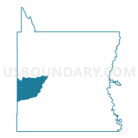
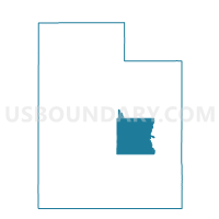
Emery 102 Voting District, Emery County, Utah
About
Outline

Summary
| Unique Area Identifier | 678821 |
| Name | Emery 102 Voting District |
| County | Emery County |
| State | Utah |
| Area (square miles) | 222.59 |
| Land Area (square miles) | 222.57 |
| Water Area (square miles) | 0.02 |
| % of Land Area | 99.99 |
| % of Water Area | 0.01 |
| Latitude of the Internal Point | 38.92527940 |
| Longtitude of the Internal Point | -111.13690870 |
Maps

Graphs
Select a template below for downloading or customizing gragh for Emery 102 Voting District, Emery County, Utah


Neighbors
Neighoring Voting District (by Name) Neighboring Voting District on the Map
- Emery 101 Voting District, Emery County, UT
- Ferron 204 Voting District, Emery County, UT
- Salina 15 Voting District, Sevier County, UT
- Unpopulated Voting District, Emery County, UT
Top 10 Neighboring County Subdivision (by Population) Neighboring County Subdivision on the Map
- Richfield CCD, Sevier County, UT (11,195)
- Salina CCD, Sevier County, UT (4,705)
- Emery-Ferron CCD, Emery County, UT (2,330)
- Green River CCD, Emery County, UT (1,132)
Top 10 Neighboring Place (by Population) Neighboring Place on the Map
Top 10 Neighboring Unified School District (by Population) Neighboring Unified School District on the Map
Top 10 Neighboring State Legislative District Lower Chamber (by Population) Neighboring State Legislative District Lower Chamber on the Map
Top 10 Neighboring State Legislative District Upper Chamber (by Population) Neighboring State Legislative District Upper Chamber on the Map
Top 10 Neighboring 111th Congressional District (by Population) Neighboring 111th Congressional District on the Map
Top 10 Neighboring Census Tract (by Population) Neighboring Census Tract on the Map
- Census Tract 9751, Sevier County, UT (4,705)
- Census Tract 9765, Emery County, UT (3,462)
- Census Tract 9752, Sevier County, UT (2,757)